The facility in its course of operations had undergone significant changes in its infrastructure of process systems, making their existing documentation (As-built drawings) obsolete.
The client was interested in further development of existing systems, to increase the overall production capacity of the facility by adding two additional conveyor lines and associated systems.
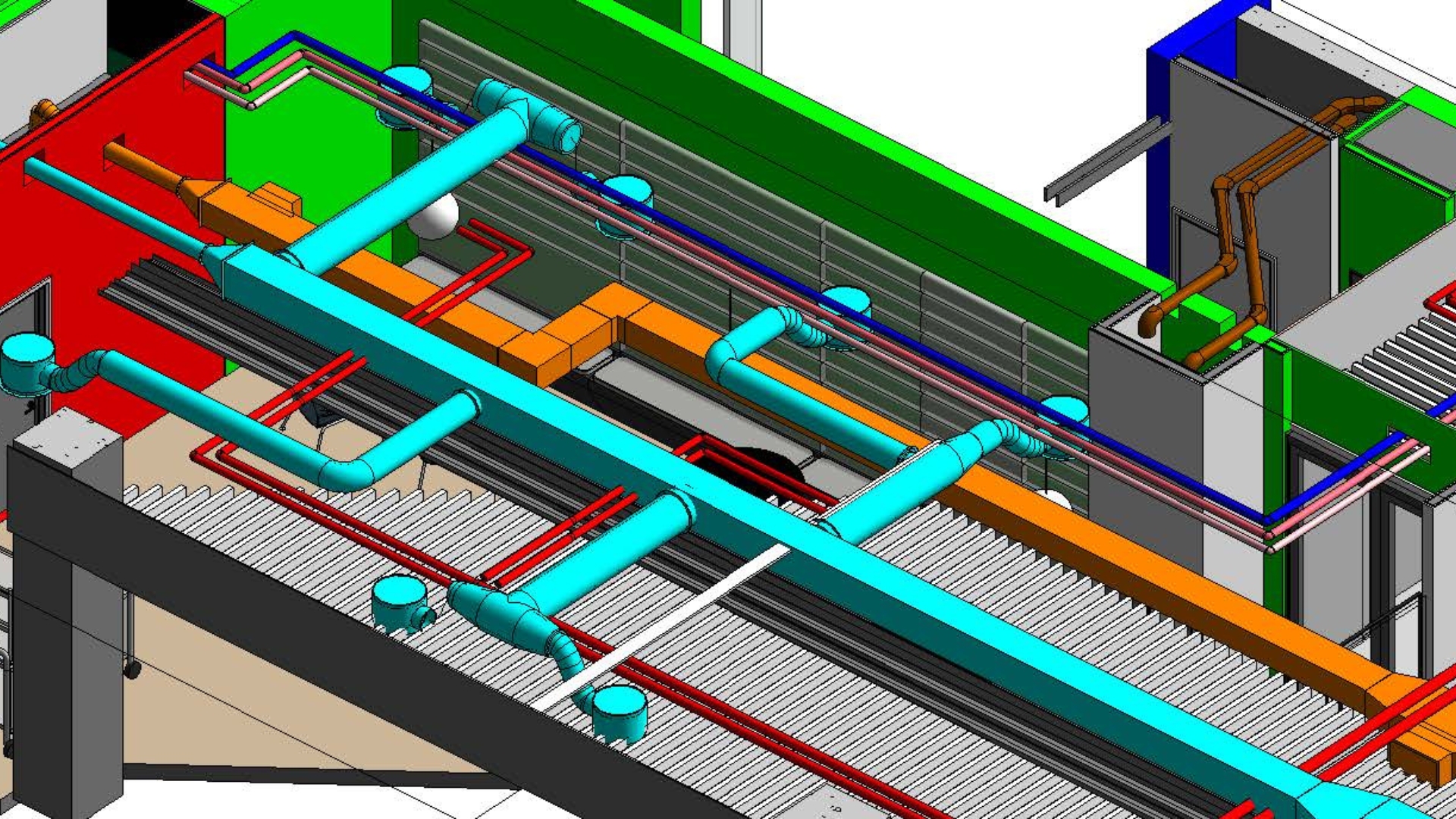
Along with this, causing issues during maintenance activities was one of the key issues they needed to address, i.e., incorrect/inaccurate position, sizes of process pipes, ducts, system connections, and overall facility civil and interior conditions, not documented right.
Infrastructure of process systems
Scope of Work
Laser Scanning, Scan-to-BIM (BIM model creation for as-built (existing) conditions)
Input shared by the client
Since the requirement was to assess existing conditions, the Desapex team visited the field to understand the specifications of the necessity and identified the critical areas of interest for capturing the existing facility.
Modeling Software - Autodesk Revit 2021 (To create BIM model of existing conditions)
Model Review Software - Autodesk Navisworks Manage 2021 (To review models and exchange comments and feedback with the client)
Common Data Enviroment - Autodesk BIM360 (To exchange files and Scanned Data with the client)
Project Timeline
From the date of onboarding - the project needed about 6 weeks for completion.
1. First 2 Weeks - Field visit, data capture and processing
Laser Scanning on the field, registration of scanned data for creating point cloud for further model development activities.
2. Next 4 Weeks - Model development and Review
Modeling and model review with the client to discuss potential modifications to the existing infrastructure and identify the best options to add additional conveyor lines.
Key Challenges & How we solved the problem
The fundamental problem with the requirement was the sheer density of processing equipment and auxiliary systems network that had to be captured to make informed decisions of the best possible retrofitting solutions. In a traditional approach, a team of 10-15 surveyors would visit the field to capture dimensions manually and then recreate the drawings in 2D. Manual processes are prone to human error, the density of services would make this a year-long process and the accuracy would be too far from the required level.
With Laser scanning and Scan-to-BIM, Desapex was able to cut the processing time to just 6 weeks, with a permanent record of the existing conditions with 360 imagery and a navigable virtual facility using a 3D BIM model.
With Laser Scanning, geometric positioning accuracies up to 4mm and further using the scanned data to BIM model, geometric accuracies of up to 10mm could be achieved in creating this as-built conditions documentation.
Another advantage we were able to provide was a clear visualization of the existing infrastructure of the process piping network, which would never have been possible to capture with mere photography. A laser scanner captures every nook and corner of the facility to document bends, offsets, and terminations in difficult spaces where human access would be next to impossible.
3D BIM model
Outcome or how the client got benefitted
The services provided to the client were directly addressed at solving the customer’s requirement of capturing existing conditions and helping them identify potential areas of modifications to retrofit the facility.
Accurate model and scanned data, measuring to up to 4mm in geometric positioning, really helped them make informed decisions about adding/removing/relocating existing and new services. This directly results in avoiding rework or surprises in the field when installing new equipment and their connections.
This helped client meet their objectives of documenting their existing conditions.
Further activities for retrofitting and adding new heavy machinery could all be done in 3D, and the client gets a point cloud and 360 imagery of their facility that can be used for navigation, use for customer/visitor presentation to critical areas and explaining the process, virtually, without having to take to security/hazard sensitive zones in the facility.


.jpg)


.png)


