


Problem statement
Regular project progress documentation with standard still photos and gantt charts is a comparatively slow and inefficient process. Every time you want to capture new progress, one of your resources has to spend hours taking photos and sorting them afterwards. It is difficult to navigate or to understand where each photo has been taken or to find a photo from a particular time and place.
Traditionally, how are construction sites documented?
Construction site progress is typically recorded by taking still images of various areas that have been subject to change. It takes a lot of photographs to document a complete construction site, and having the discipline to take pictures of every area of the project is a challenge. In a collection of folders and subfolders, thousands of point and shoot images are also processed. Unfortunately, in this traditional folder layout, it is difficult to navigate, which makes it difficult to understand where each photo has been taken or to find a photo from a particular time and place. Still some projects use only Gantt charts which are prepared by the inputs given by the site team for progress monitoring.
Digital Construction progress monitoring
Ability to see the jobsite status remotely is a game changer
Digital Construction progress monitoring replaces the ineffective project documentation process of taking daily photos and uploading them to asset repositories.
This old method of creating project transparency wastes valuable time at the jobsite and makes it difficult to make informed decisions. Using the latest digital technology like laser scanning, 360 degree images, Dalux, & Trimble field link is the easiest and most effective solution for comprehensive project documentation.
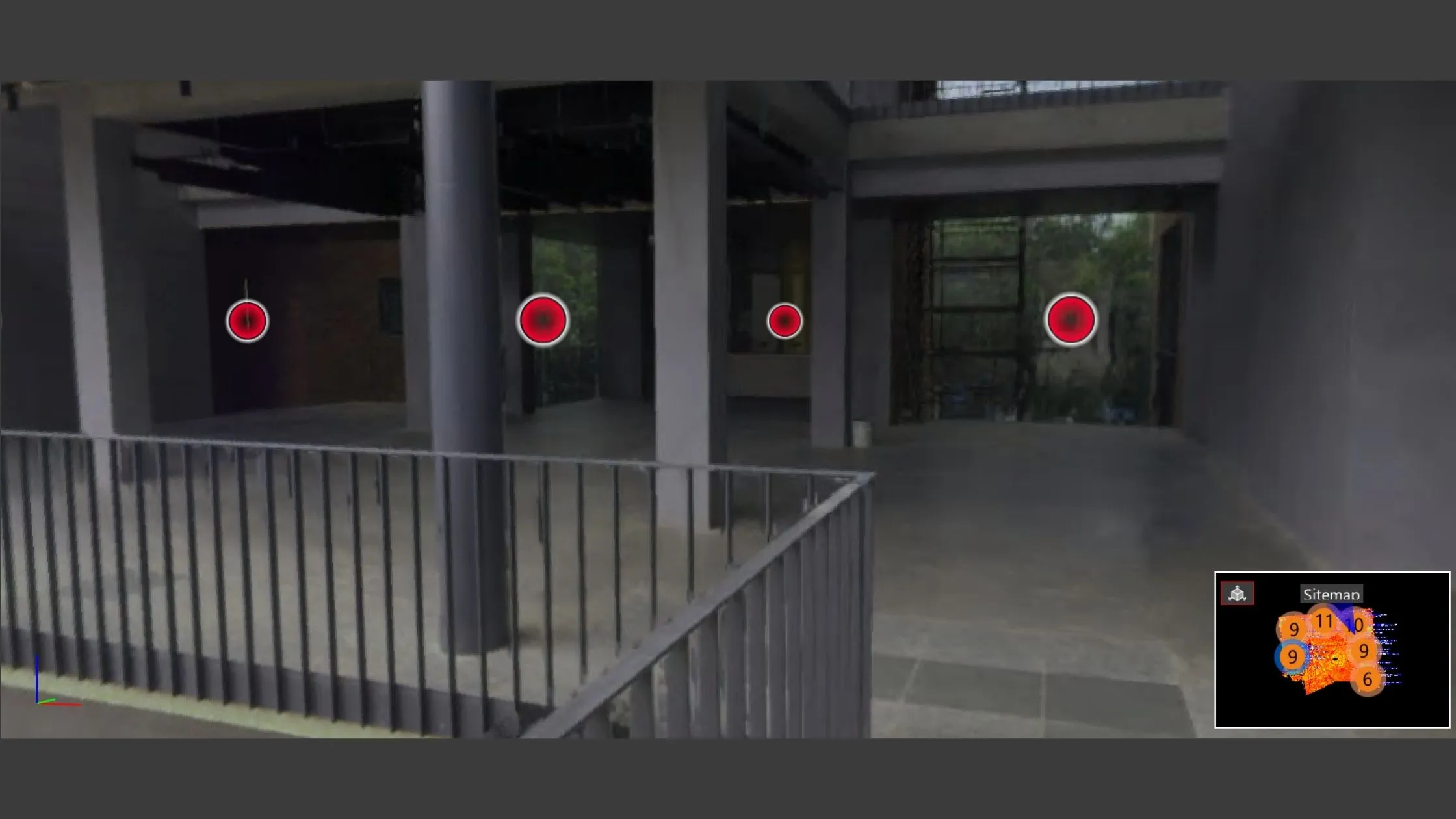
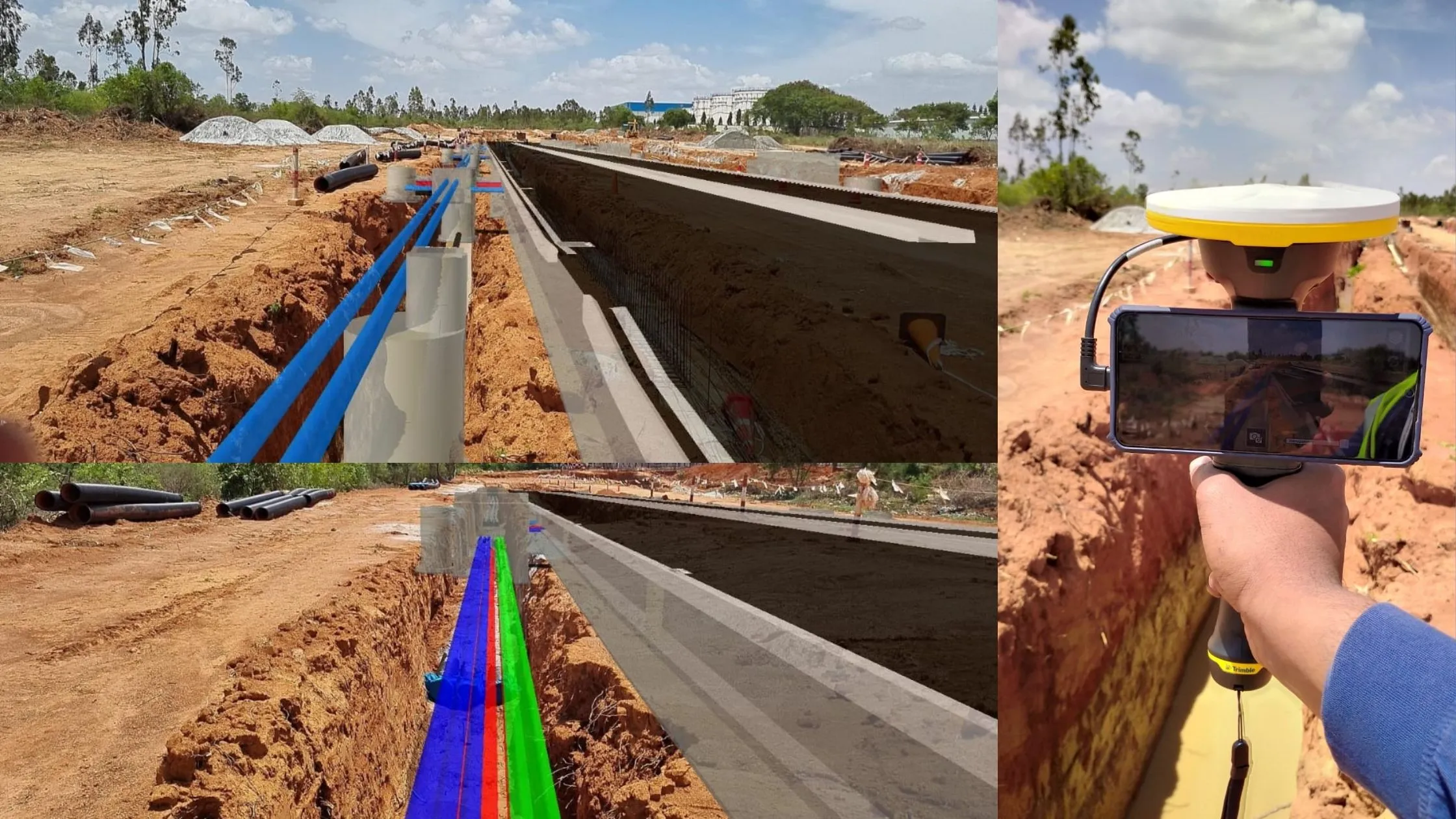
You just need to upload the floor plan and pin the location of the 360 pictures and scan data to the floor plan you uploaded, we capture the real time data of the entire floor for documentation. Then, you can view any spot within the project as if a 360° photo was taken there. You can see the sitemap in Fig1. The path or the scan positions on the floor plan helps the team to navigate to the particular location & time to view the actual site conditions. Users can access from anywhere and walk through the space, can compare with time period, can do the measurement, can raise Comments, RFIs & Clams to responsible parties and responsible parties can look into and respond from anywhere, can compare space with the BIM model.
How laser scanners are used for progress monitoring
BIM to Field:
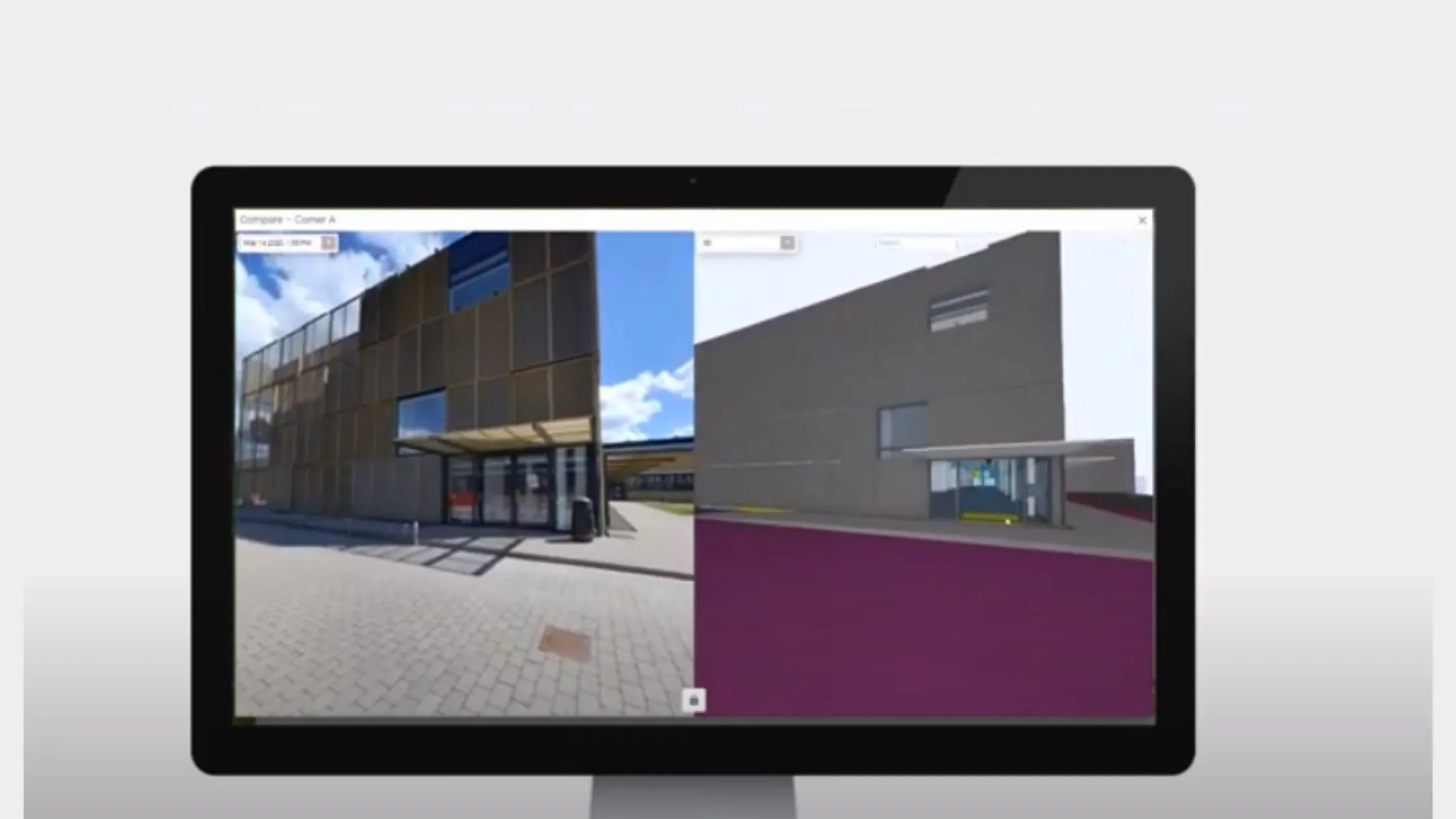
Leverage the BIM to its full potential, tools allow one to compare the actual field conditions to the BIM model. Trimble X7 and field link software helps us do live scan to model inspection. When you have the real time scan data of field conditions you can compare the field condition to model and extract the quantum of work that has been completed. The great advantage of the using laser scanner is along with the progress you can inspect the quality of the work performed. Trimble Realworks has some of the interesting inspection tools like, volumetric, Floor Flatness and floor level inspection test and it generates the report as per ASTM standards.
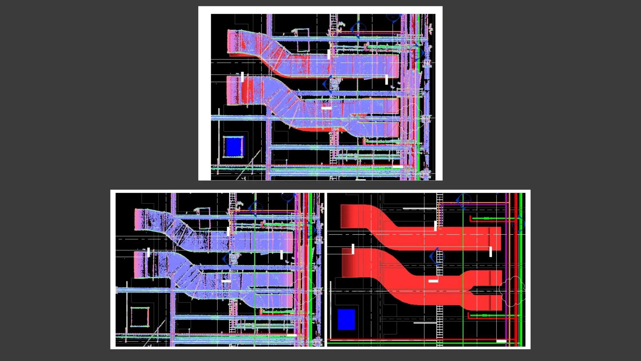
It's not just for buildings alone, Trimble realworks have tank and tunnel inspection as well. The live scan data of actual field conditions linked to the model is shown in the fig. Comparing the actual site conditions to BIM models can also help engineers determine what they are working on and how much progress has been made for WIP reports.
A key benefit of virtual job walks is that, on the virtual work site you can quickly orient yourself, understand both where you are and what you can do next.
The documentation is no longer composed of disconnected images, it is a virtual construction site.
Common Data Environment (CDE) :
Digital documents are protected from physical damage at all times since they are stored in a cloud database. These documents can be accessed from multiple devices simultaneously which allows annotations and discussions without the need of physical contact with the help CDE (Common Data Environment). Annotations can be reviewed by architects and engineers quickly making the flow of information more efficient. Storing physical construction documents, over time this could introduce difficulties for finding a specific document for a collaborator who is unfamiliar with projects or while dealing with construction clams.

4D for construction progress monitoring :
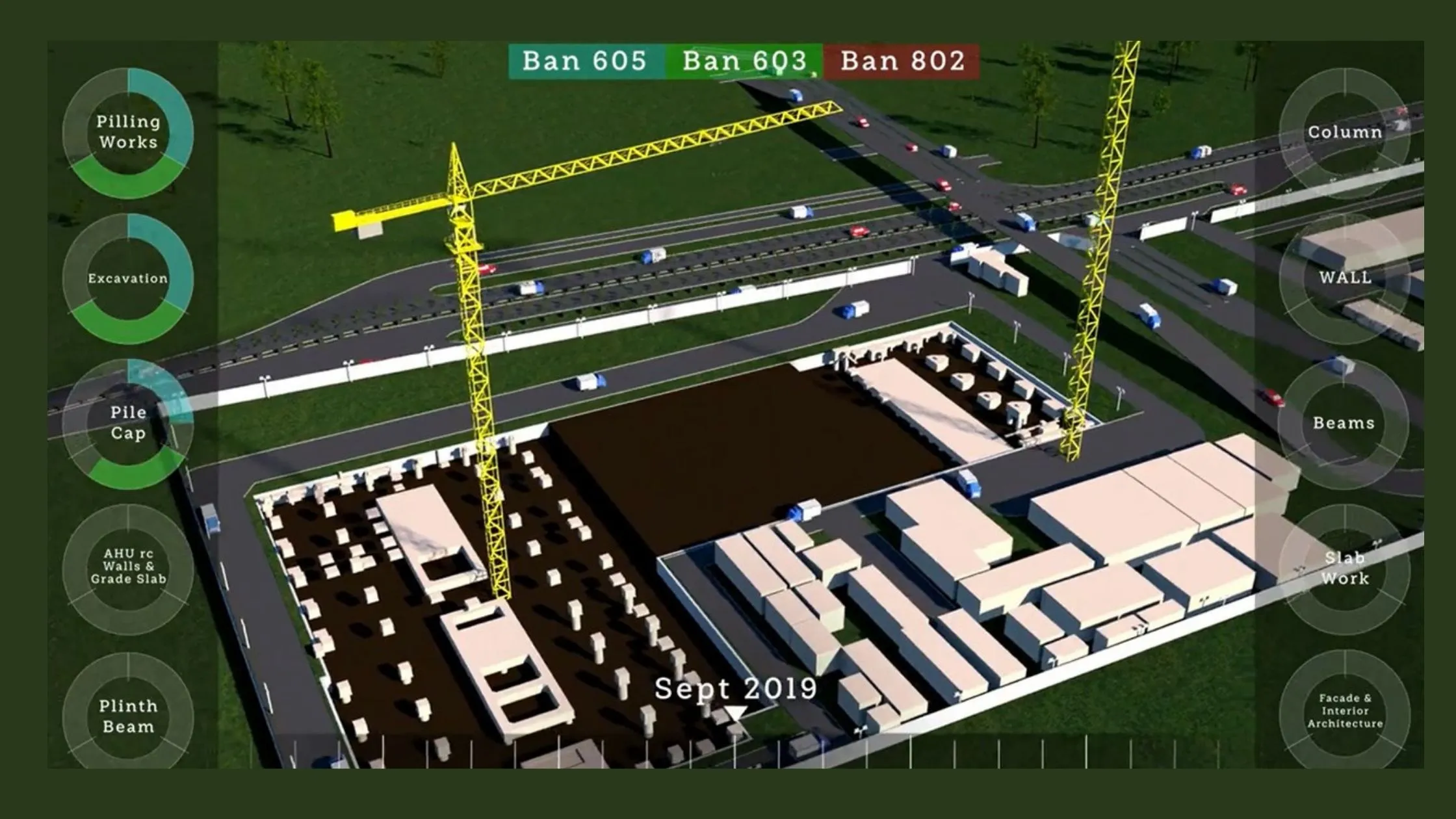
4D planning is an extended and deeper version of conventional planning that develops the construction planning to a higher level of detail to provide greater accuracy and less risk.
4D BIM allows planners to communicate visually and to schedule activities in time and space by linking the construction plan to the 3D model.
In project planning, 4D progress tracking plays an important role, as it involves significant data such as the start and end date of each portion and its criticality. The 4D model helps get minute information from the project team.
The project team will check various options and choose the most suitable one at the project design stage, as it visualizes the assembly of a building over time. With the aid of BIM 4D progress tracking, ahead of the construction process, we can identify and address the conflicts between space and workspace. It conveys the project's data and spatial dynamics and also helps to carry out additional analyses.
Augmented Reality :
Getting as-built site data back, like scan data or taking photos, and then use it to compare with BIM models. Such an approach can only stop the problem and take corrective reactive measures in the project but with the help of AR technology can act as a proactive measure to identify the problem before it occurs and this will speed up the construction process, by reducing reworks and easily eliminating risks.
Efficient visualization and communication of the results is essential to an effective progress monitoring system.
Augmented Reality (AR) technology offers to visualize, measure, collaborate and report the progress of a project.
Benefits of Digital Construction Progress Management
Reduces travel, improves productivity, saves time & cost: getting the right people to the site at the right time is a great challenge. With the help of digital construction progress management tools one can Verify jobs, endorse orders for improvement, minimize the risk, and eliminate on-site problems wherever you are and save time and money on countless job trips.
Better collaboration: Near-real-time updated documentation allowed PMCs to communicate more effectively with contractors and internally, saving hundreds of hours in back and-forth communications and preventing miscommunication.
Deliver on time and under budget: digital construction progress management ground truth is it accelerates project execution, eliminates budget overruns due to rework and change orders, and helps you to better manage risk and liability, ensuring the best quality.
Access Virtual construction site: experience and view the construction site anytime, anywhere by just clicking on the link. Never be without the documentation that you need.
Manage the crews efficiently: Without clear records of what is being done, and how soon, it's difficult to quantify efficiency. We often see efficiency issues too late. Digital progress management tools help you to quickly see what is happening on site so that you can assess the productivity of your crews and schedule the work better.
Conclusion
Digital construction progress monitoring tools help us to provide great quality work at our job sites consistently.
The ability to see the jobsite status remotely from your central corporate office is a gamechanger.
Top level management can overcome the challenges they face to manage projects remotely. Desapex working towards digital transformation in the construction industry, get in touch with Desapex to know more and implement our services to add value to your projects.