


Introduction
GIS is a computer-aided system that uses geographic information to produce maps, databases and other data sets. It has become an indispensable tool in various fields such as engineering, construction, land surveying and geology among others; it can help you plan and manage your projects in a better way with great accuracy.
GIS applications in the construction industry
GIS is a technology that helps you plan and manage your projects in a better way with great accuracy. It can help you improve your project management, planning, and scheduling, as well as cost-effectiveness.
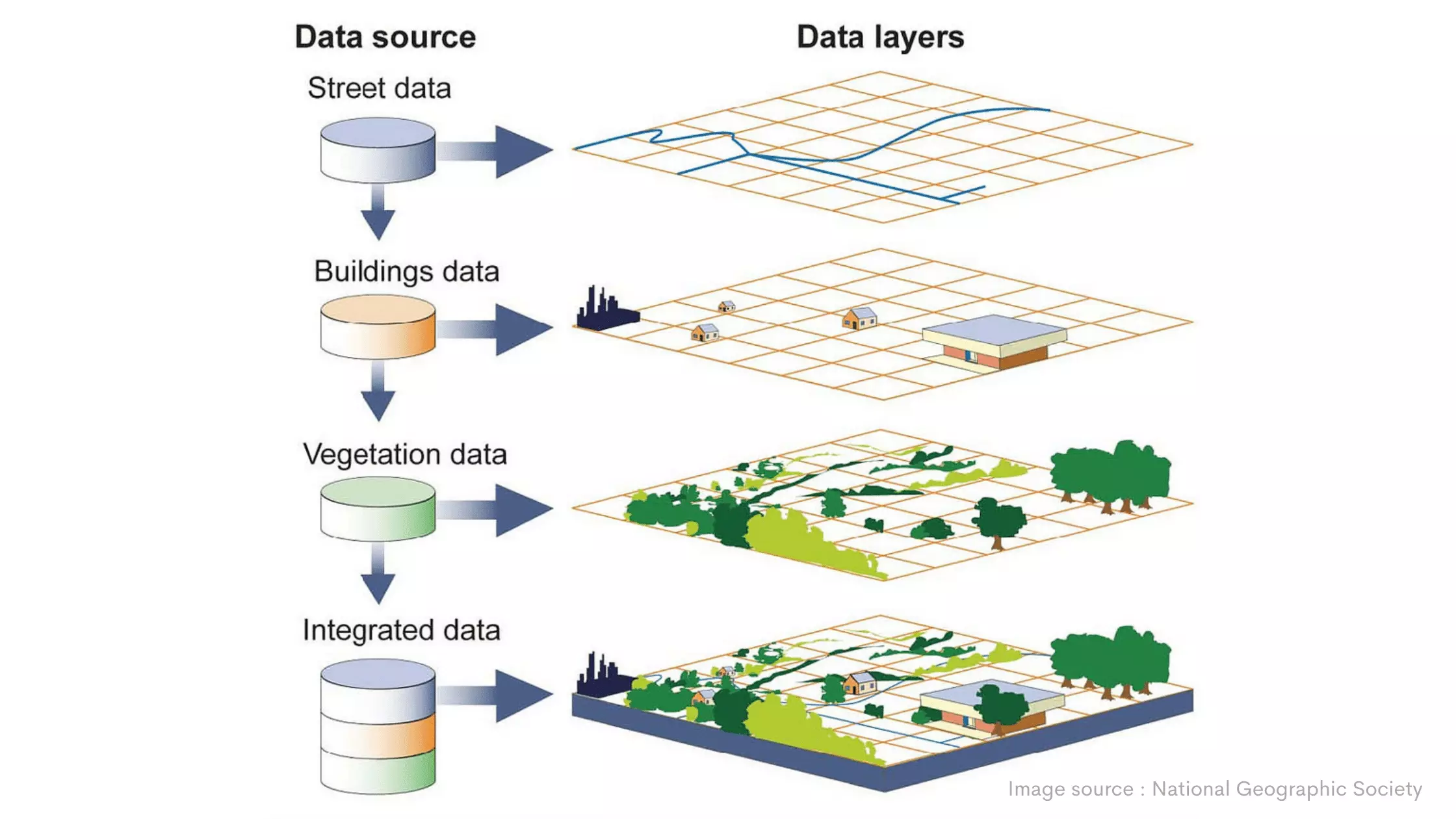
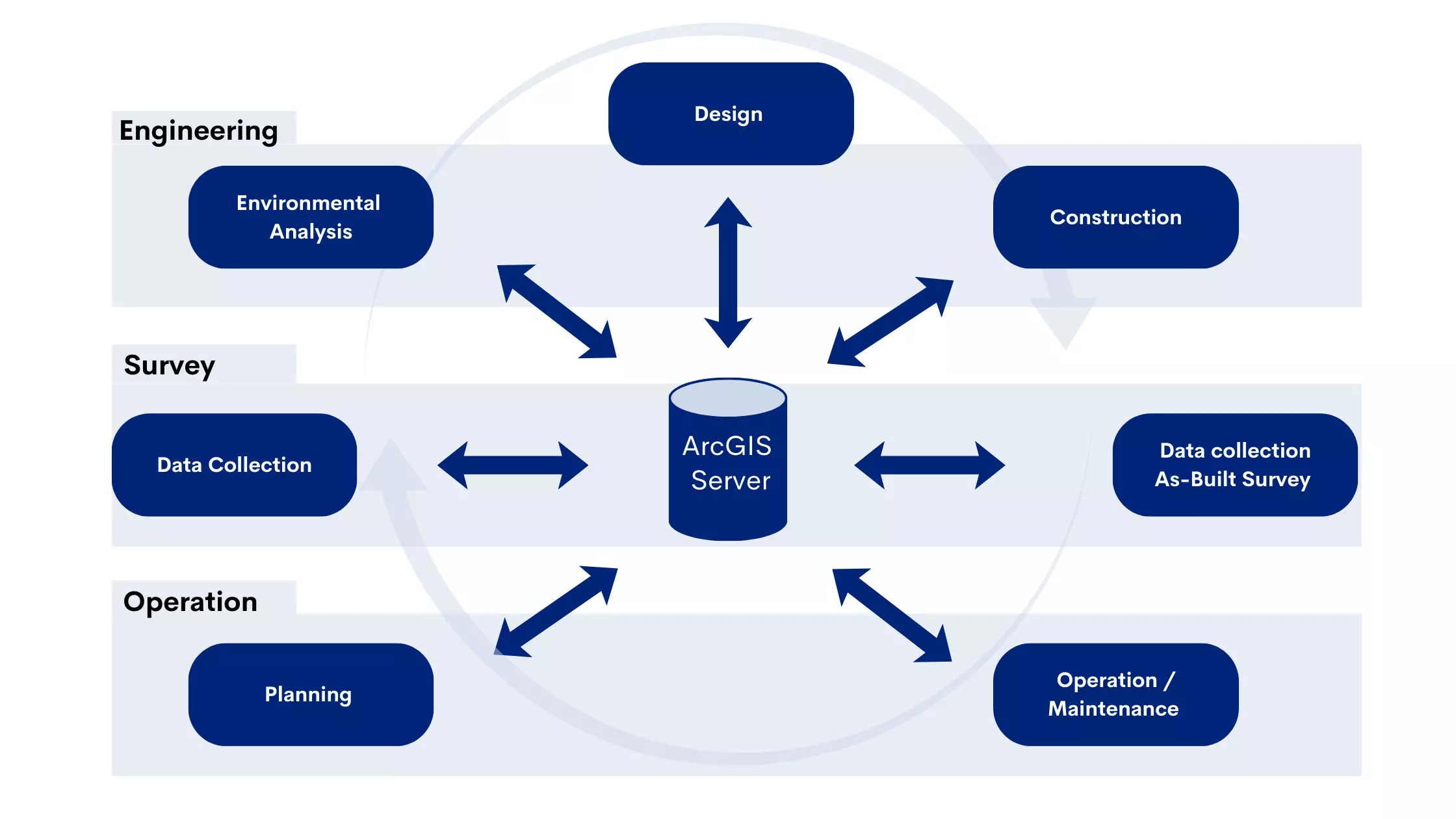
GIS applications in the construction industry are used to monitor the progress of a project or maintenance activities on-site at any time during its life cycle. These applications provide information on spatial data such as map views (visualization), 3D models of buildings/structures, etc., which can be used for various purposes including management decisions concerning resources allocation between different phases/stages of construction work; monitoring changes in existing conditions over time; tracking resources consumption during different phases/stages, etc., thereby reducing risk factors associated with failure due to lack of visibility into actual spending patterns before the launch date.
Planning and scheduling applications
GIS is a great tool for planning and scheduling. It can help you plan and schedule your projects, manage your resources, manage your budget, and more.
In the construction industry, GIS applications are used in many different ways to manage construction projects from beginning to end. Some examples include:
1. Infrastructure and Hi-Tech infrastructure applications
GIS can help you plan and manage your projects in a better way with great accuracy. It is a software that helps you to analyze and visualize complex data using a geographical information system (GIS). GIS has a huge range of applications for construction industries like land planning, construction management, project development, etc.

2. Maintenance and management applications
GIS is also used in construction management and maintenance. It helps you to plan, manage and monitor your projects in a better way with great accuracy.
GIS can help you understand the impact of your decisions and actions on the project, which helps in identifying problem areas or risks early on. This will help you make better decisions about how to resolve them so that they don't become major issues later on during the construction or operations phase. It's also useful for identifying trends over time so that you can take corrective measures if needed.

3. Environmental and safety applications
GIS technology can help you plan and manage your projects in a better way with great accuracy.
GIS is an essential tool for any project manager or engineer, who has to coordinate activities between different departments of the construction company. It simplifies the process by making it easier to identify locations of interest (such as water bodies), assess environmental impacts on these areas, etc.
4. GIS technology can help you plan and manage your projects in a better way with great accuracy
GIS technology can help you plan and manage your projects in a better way with great accuracy. GIS is used to analyze and plan construction projects, manage and monitor them, as well as manage and monitor environmental issues. It helps to identify problems before they happen so that you can avoid them at the earliest possible time.
Benefits of GIS in the construction industry
GIS offers many benefits for construction companies, including:
Improved project planning and decision-making - GIS can provide detailed information on site conditions, such as terrain, vegetation, and soil types, helping construction companies make informed decisions.
Reduced costs - GIS can help construction companies identify potential hazards and optimize construction schedules, leading to reduced costs and increased efficiency.
Increased efficiency - GIS can help construction companies streamline workflows, improve communication, and reduce errors.
Improved stakeholder engagement - GIS can provide stakeholders with detailed information on project progress and potential impacts, improving communication and engagement.
Conclusion
GIS technology is a powerful tool for planning and managing construction projects. It can help you make better decisions by enabling you to analyze your project data, identify potential problems and correct them before they become big problems. Furthermore, it provides real-time updates on the state of your work site so that managers can keep an eye on what needs to be done at any given time. GIS also has other applications like environmental management which help in monitoring air quality among others.